
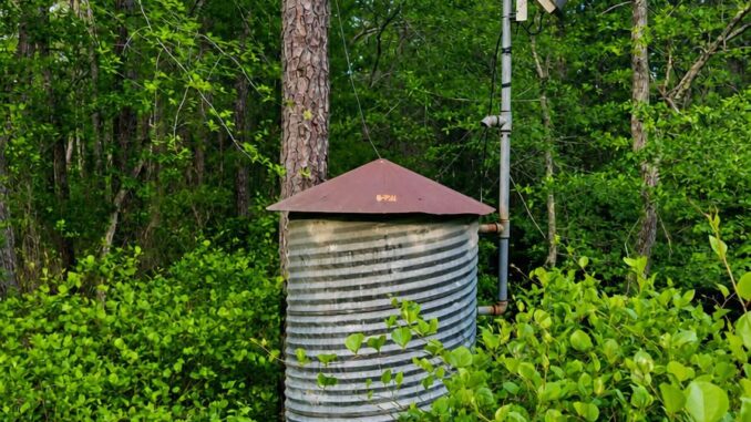
At first glance, a small creek flood gauge standing alone in the forest can look like a relic from another time.
There may be a short, corrugated metal cylinder tucked among the trees, a solar panel angled toward the sky, and a pole supporting a box that seems to have no obvious purpose. The entire setup can look oddly out of place—and yet, at the same time, strangely at home in the woods.
It doesn’t look like a modern piece of technology.
It doesn’t make noise.
It doesn’t have flashing lights or a giant warning sign explaining what it does.
Instead, it sits quietly beside the creek, blending into the vegetation and waiting for something most people would never notice until it becomes a problem: rising water.
To a passing hiker, the equipment might look abandoned. A curious deer could walk past it without a second thought. Birds might perch on it. Leaves can accumulate around its base.
But the station is likely doing something important.
It is watching the creek.
And that peaceful little stream flowing through the trees may be much more significant than it appears.
On an ordinary day, a creek can be one of the calmest features in a landscape. It winds between rocks, passes beneath branches, and produces the familiar sound of moving water. You might cross a small bridge over it without giving the creek another thought.
Then a major storm arrives.
Heavy rain falls upstream.
The ground becomes saturated.
Water begins running downhill faster than the landscape can absorb it.
Within a surprisingly short amount of time, that quiet creek can become swollen, muddy, fast-moving, and dangerous.
That’s when a small monitoring station like this becomes especially valuable.
What Does a Creek Flood Gauge Actually Do?
A creek flood gauge is generally part of a monitoring station designed to measure conditions in a stream, creek, river, drainage channel, or nearby watershed.
One of the most important measurements is water level, commonly referred to as the stream’s stage.
Stage is essentially the height of the water surface at a particular monitoring location relative to a defined reference point.
That number may seem simple, but changes in stage can tell scientists, emergency managers, transportation officials, and other agencies a great deal about what’s happening in a watershed.
If the water level is rising quickly, for example, that can indicate that substantial amounts of water are moving through the creek.
A gradual rise may be routine.
A rapid rise can be a warning.
And when that information is collected continuously, it can provide valuable time for people responsible for roads, bridges, emergency response, flood warnings, and public safety to understand what is happening.
The station doesn’t necessarily “predict” a flood by itself.
Instead, it provides measurements.
Those measurements can then be compared with established thresholds, historical records, forecasts, rainfall information, and other observations to help officials understand the potential for flooding.
In other words, the little station isn’t sitting there making dramatic decisions.
It’s gathering evidence.
And evidence is incredibly useful when water begins moving where it shouldn’t.
What’s Inside That Little Metal “Silo”?
The exact equipment varies from one monitoring station to another, so you can’t know the contents of a particular installation just by looking at a photograph.
But a remote monitoring station may contain equipment such as data loggers, batteries, wiring, communication components, protective electronics, and other control or measurement devices.
The corrugated cylindrical structure provides a practical enclosure for equipment that needs protection from weather and the surrounding environment.
Think of it as a tiny utility building.
It doesn’t need windows.
It doesn’t need a door you can walk through.
It simply needs to keep the equipment inside protected enough to continue operating.
And because these stations are often located far away from houses, offices, or other buildings, they may need to generate their own electricity.
That’s where the solar panel comes in.
During daylight hours, the panel can provide power for the station and help charge batteries used when sunlight isn’t available.
That arrangement makes a great deal of sense in a remote forest.
Running electrical lines through the woods just to power a small monitoring station would be expensive and impractical.
A solar-powered system can operate independently.
It can sit beside the creek for months or years without requiring someone to visit every day.
What Is the Pole-Mounted Box Doing?
That box attached to the pole is another clue that this isn’t an abandoned piece of farm equipment.
Depending on the particular monitoring system, a pole-mounted enclosure may contain communications equipment or other components used to transmit collected information.
Modern monitoring stations can communicate in different ways depending on their location and available infrastructure.
Possible communication methods include cellular networks, radio systems, satellite communications, or other wireless technologies.
Again, the exact technology varies.
But the basic concept is straightforward.
The station measures something.
The equipment records that measurement.
The information is then transmitted or retrieved so it can be used elsewhere.
That means the little metal structure isn’t merely measuring water for its own benefit.
It’s potentially part of a larger network of environmental monitoring.
One station may be quietly collecting information while another monitors rainfall somewhere upstream and another tracks conditions at a bridge.
Together, these observations can help create a much clearer picture of what’s happening during a storm.
Why Monitor Such a Small Creek?
This might be the most important question.
After all, nobody is particularly surprised when a major river rises during a storm.
But small creeks can be deceptive.
Most of the time, they look harmless.
They’re narrow.
They’re shallow.
You can often see the rocks on the bottom.
The water may barely cover your shoes in some places.
That peaceful appearance can make it easy to underestimate how quickly conditions can change.
A small creek can respond rapidly to rainfall because there is less water volume to absorb the sudden increase in flow.
When heavy rain falls across a watershed, water begins moving across the landscape.
Some of it soaks into the soil.
Some is temporarily stored in vegetation or other surfaces.
Some enters drainage systems.
And some eventually reaches streams and creeks.
If the rainfall is intense enough, the amount of water entering a creek can increase dramatically.
The result can be a rapid rise in water level.
A person who walked beside the creek in the morning may return a few hours later to find something that looks completely different.
The water may be brown with sediment.
Branches and debris may be moving downstream.
The current may be dramatically faster.
The banks may be overtopped.
And places that seemed completely safe earlier can become hazardous.
Small Creeks Can Rise Quickly
One of the reasons flood monitoring matters is that flooding doesn’t always happen on a schedule that gives people plenty of time to react.
Large rivers can sometimes take many hours or even days to respond to a major rainfall event, depending on the size and characteristics of the watershed.
Smaller streams can react much faster.
The exact response depends on many factors, including rainfall intensity, watershed size, soil conditions, terrain, vegetation, drainage patterns, and whether the area has already received substantial rain.
When the ground is saturated, additional rainfall has fewer places to go.
Water begins moving across the surface and into drainage channels.
That water eventually concentrates in streams.
And once enough water reaches the creek, the creek rises.
This is why a monitoring station tucked into what appears to be an insignificant patch of woods can actually be valuable.
The station is positioned where the change is happening.
It’s watching the water when humans aren’t there.
What Happens When the Water Starts Rising?
The gauge itself doesn’t necessarily cause anything to happen.
Instead, its measurements can become one piece of information used by people and systems responsible for flood monitoring.
Suppose a creek normally stays at a relatively low stage.
Then a major storm moves through.
The station begins recording a rapid increase.
That information can help confirm that the creek is responding to the rainfall.
If the water reaches certain established levels, authorities may already have procedures associated with those thresholds.
Depending on the location and the severity of the situation, information from stream gauges can support decisions involving road closures, bridge monitoring, public warnings, emergency response, or other protective measures.
The exact response varies by community and by the characteristics of the monitored location.
A gauge near an important roadway may have very different practical implications from one located deep in an undeveloped watershed.
But in either case, having actual measurements is better than relying entirely on guesswork.
What Can the Data Tell Us Over Time?
The usefulness of a creek gauge isn’t limited to dramatic storms.
One of the biggest advantages of continuous monitoring is that it creates a record.
Over time, that record can show how a creek behaves under different conditions.
Researchers and water-resource managers can examine how quickly the creek responds to rainfall.
They can compare water levels during different storms.
They can identify unusually high stages.
They can examine seasonal patterns.
They can also use long-term observations to improve understanding of flood risk and watershed behavior.
Imagine two creeks that look almost identical during a dry summer afternoon.
One might respond very quickly to heavy rain.
The other might rise more slowly.
Without measurements, those differences may be difficult to quantify.
With monitoring data, they become much easier to understand.
That information can contribute to planning, engineering, flood-risk assessment, and environmental research.
So that tiny station beside the creek may be contributing to a much larger body of knowledge.
A Modern Version of Local Knowledge
There is something interesting about the way technology has changed how people understand waterways.
For generations, people living near creeks and rivers relied heavily on observation and local knowledge.
Someone who had lived in the area for decades might know exactly which road flooded first.
They might remember which bridge became dangerous after a major storm.
They might know how high the creek typically rose during spring runoff.
They might even recognize that something was unusual simply by listening to the water at night.
That knowledge was practical.
It was built through experience.
Modern monitoring systems don’t eliminate the importance of local knowledge, but they provide another way to observe the same natural processes.
Instead of relying solely on someone standing beside the creek with a measuring stick, a sensor can record conditions continuously.
Instead of waiting for someone to notice that the water has risen, an automated system can collect measurements around the clock.
And unlike a human observer, the station doesn’t need sleep.
It doesn’t get bored.
It doesn’t go home because the weather is unpleasant.
It just keeps measuring.
Why Does the Equipment Look So Old-Fashioned?
There’s also something charming about the appearance of these stations.
Modern technology is often associated with sleek plastic housings, glowing screens, tiny circuit boards, and polished surfaces.
This equipment looks different.
The corrugated metal enclosure can resemble a miniature grain bin or an old agricultural storage container.
The solar panel looks distinctly modern, but the rest of the installation can have a rustic, almost industrial appearance.
That combination makes it easy to mistake the station for something abandoned.
But practical equipment has never necessarily been beautiful.
Consider old pump houses.
Water tanks.
Windmills.
Cisterns.
Barn equipment.
Railroad signal structures.
Hand-operated pumps.
Many of these objects were built for one purpose: to work.
Their appearance was secondary.
A creek monitoring station follows much the same philosophy.
It doesn’t need to win a design award.
It needs to survive rain, snow, heat, wind, insects, vegetation, and curious wildlife while continuing to collect useful information.
If it can do that quietly for years, it’s doing its job.
A Tiny Station With a Big Responsibility
There’s something reassuring about discovering functional infrastructure in unexpected places.
We tend to notice infrastructure only when it fails.
We notice roads when they’re closed.
We notice bridges when they’re damaged.
We notice power lines when the electricity goes out.
We notice drainage systems when water floods a street.
But much of the time, infrastructure works quietly in the background.
A creek gauge is an excellent example.
Most hikers will walk past it without knowing what it does.
Most people driving over a nearby bridge will never think about the sensor collecting data upstream.
Yet that information can contribute to the systems used to understand and respond to flooding.
It’s a reminder that some of the most useful technology is almost invisible.
Don’t Assume the Creek Is Safe Just Because It Looks Calm
Perhaps the most important lesson from these little stations has nothing to do with technology.
It’s about respecting water.
A calm creek can become dangerous surprisingly quickly.
During heavy rainfall, water levels can change faster than people expect.
Floodwater can also contain hidden hazards, including debris, unstable banks, submerged objects, and strong currents.
A creek that looks shallow may have a much stronger current than its appearance suggests.
That’s why monitoring equipment should be thought of as a reminder rather than an invitation to get closer to the water.
If you’re hiking near a creek and severe weather is approaching, give the water plenty of space.
Never assume that a familiar crossing will remain safe simply because it was safe earlier in the day.
Water doesn’t care how peaceful it looked five minutes ago.
So, Is That “Abandoned” Silo Actually Important?
Very possibly.
Without identifying the exact station and its equipment, it’s impossible to say precisely what every component in a photograph is doing.
But the combination of a creekside enclosure, solar panel, pole-mounted equipment, and nearby water is consistent with the kind of remote monitoring infrastructure used to collect environmental data.
What looks like an abandoned metal cylinder may actually be part of a carefully designed system.
It’s measuring.
It’s recording.
It may be transmitting information.
And it’s doing all of that without attracting much attention.
That is perhaps the most fitting quality of the entire setup.
The creek itself is quiet.
The equipment is quiet.
The monitoring happens quietly.
And yet the information collected there can become especially important when the creek stops being quiet.
The Next Time You See One
The next time you encounter a strange metal container beside a creek, don’t automatically assume you’ve discovered an abandoned piece of farm equipment.
Look around.
Is there a solar panel?
Is there a pole-mounted enclosure?
Is there a stream or drainage channel nearby?
If so, you may be looking at a monitoring station.
And that little structure is likely doing something much more useful than sitting forgotten in the woods.
It’s keeping watch.
Day after day, season after season, the station can quietly record changes in the waterway.
Most of the time, nothing dramatic happens.
That’s exactly what you want.
The creek flows.
The sensor records.
The sun powers the equipment.
The data moves along.
Then, perhaps once or twice a year—or during an unusually severe storm—the numbers begin changing quickly.
The water rises.
The creek becomes turbulent.
And suddenly, that unassuming little “silo” beside the trees becomes part of an important network of information.
It may never look impressive.
It may never appear on a postcard.
It may spend most of its life unnoticed by the people walking past it.
But that’s the beauty of practical infrastructure.
It doesn’t need to look important to be important.
That small creekside station is a quiet example of how modern technology can work alongside the natural world, watching the water without interfering with it and collecting information that can help people better understand the risks around them.
So the next time you see one tucked away in the woods, take a second look.
What appears abandoned may actually be one of the most attentive things in the forest.
Leave a Reply